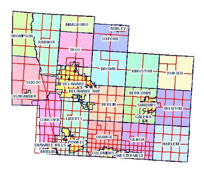
Cadastral Maps are maps that shows ownership and boundaries. This particular map is a map of Delware County in Delware, Ohio. The sections are color coordinated in order to show the boundaries. The sections are also clearly labeled with names in order to give more distinction of the ownership. This is a form of a land partitioning system.
This map was taken from http://www.dalisproject.org/(S(mcnlbx55sbjep255ckkset55))/pages/findMapsheet.aspx
I am really surprised by the quality of your constant posts.You really are a genius, I feel blessed to be a regular reader of such a blog Thanks so much..Plz Visit My Blog-
ReplyDeleteOnlinekaj.com
অনলাইন বয়স ক্যালকুলেটর | Boyos Calculator Online
Mobile-price-bd.com