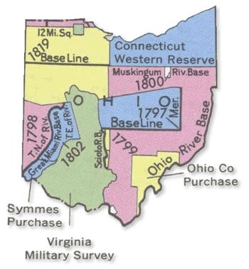
PLSS Maps are created from the Public Land Survey System, which divides the land of the United States into ownership. It is a prime example of systematic land cadastral system. This map shows the partitioning of Ohio into various sections based upon a system that was not fully developed. It is not based upon the Principal Meridians. The sections that are shown the Virginia Military Survey, the Ohio Co. Purchase, and the Connecticut Western Reserve, to name a few.
This map was taken from http://rnp782.er.usgs.gov/atlas2/articles/boundaries/a_plss.html
No comments:
Post a Comment