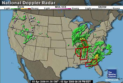
Doppler Radar is primarily used to track weather across our country. It searches for the motion of clouds, changes in pressure, and particles in the air. Doppler Radar images may seem like that should be very easy to read; however, there is a lot more science to it than what is portrayed on weather reports. This particular Doppler Radar indicates severe rain in the southeastern United States and up towards the Great Lakes. This radar image was from April 3, 2009 at 1:38 GMT.
This image from taken from http://www.weather.com/maps/news/forecastsummary/usdopplerradar_large.html. However, the image has changed since the weather has changed. Therefore, this radar image can no longer be viewed. It has been replaced by the most current images that radars are gathering.
No comments:
Post a Comment