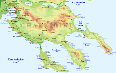
 DEM maps are known as Digital Elevation Maps. They display data on the elevation of land masses. DEM maps are forms of topographical maps. This particular map shows the elevation of Greece. The elevation is depicted by various color changes present on the map; however, there is no legend that shows what the colors correspond to. This map was taken from http://commons.wikimedia.org/wiki/File:Chalkidiki_-_DEM_Map_Topo_-_DE.png.
 Thursday, April 9, 2009
DEM Maps
 DEM maps are known as Digital Elevation Maps. They display data on the elevation of land masses. DEM maps are forms of topographical maps. This particular map shows the elevation of Greece. The elevation is depicted by various color changes present on the map; however, there is no legend that shows what the colors correspond to. This map was taken from http://commons.wikimedia.org/wiki/File:Chalkidiki_-_DEM_Map_Topo_-_DE.png.
Subscribe to:
Post Comments (Atom)
No comments:
Post a Comment