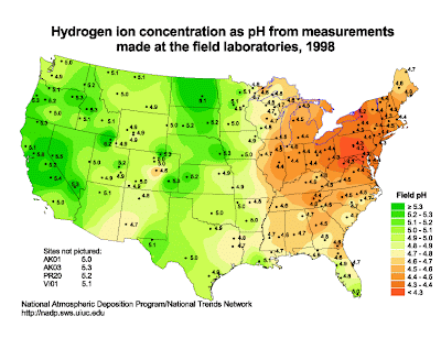
 Isopleth maps are contour maps respresenting various data. They can display variables such as temperature, pressure, wind, rain, etc. There are many types of isopleth maps, including
 Bathymetric maps, isohyet maps, and isotach maps. This particular map shows pH concentrations throughout the United States. These pHs were gathered in field laboratories. The legends shows that various colors are used to present the varying pH values. The data was collected in 1998. The map was taken from http://nadp.sws.uiuc.edu/isopleths/maps1998/phfield.gif
No comments:
Post a Comment